Showing posts with label Geography. Show all posts

Monday, February 19, 2007

Orlando Floods

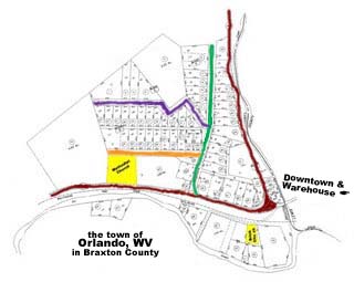
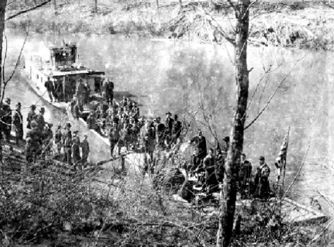
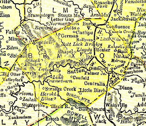
Click on the photos to enlarge them.

Orlando, at the junction of the two arms of Oil Creek, the left branch and Clover Fork, floods maybe twice a year. It isn't the life threatening deluges that towns further down the waterways knew before the dams were built, (See the entry in Oct '06, Burnsville Floods.) The biggest problem these days is that the roads become impassable. If you know the area, you can usually find another way to get where you're going, but it might take you 20 miles or so out of your way. Still, nature shows its force, crops and property can be lost, and you've got a mess to clean up, especially if your buildings are not above the high water line.

Two floods are shown here. Neither was a record breaker for Orlando and neither resulted in loss of life, although the cleanup is never fun.

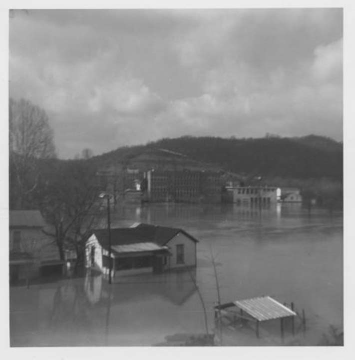
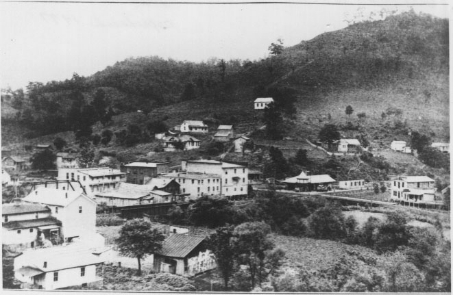
The top two photos, left and right, are from the flood of November, 1985. Both are taken from the The Rusmisell & Fury Addition on the hill looking down on Oil Creek near the red brick church. About where the white house is situated in the photo to the left, the Rush Hotel stood when Tom Jeffries was a boy. In a Feb '07 entry, Childhood in Orlando, Tom Jeffries remembers "going to the old [Rush] hotel building after the flood of 1950 with my mother and my Aunt Opal (Jeffries) McCrobie to clean up the lower floors. There was about an inch of mud on the floors. It was quite a nasty job."

The three photos at the bottom here are from a flood in February 2004 which was not nearly as high. The upper left photo below is looking east, up Clover Fork, from in front of the store. The lower left photo turns around and faces west, showing the warehouse on the left. Notice that the cement foundation of the store is built far above this high-water line and the pilings the warehouse is built on hold the wooden floor above the damages of this, and most, Orlando floods. On the right you are looking on the other side of the bridge across Oil Creek, looking west toward Oil Creek Road, coming in from Burnsville. The top of the creekbed is well below the water line. Even the rail road tracks and the road are well below water, as are the floors of the homes that sit next to Oil Creek.

Thanks to Sandy (Burgett) Conrad for both sets of photos.

Tuesday, December 19, 2006

Orlando From Henline Hill

From David Parmer:
"This is Orlando as it was seen about 1920 from Henline Hill looking toward the Catholic Church. The structure beside the church I believe was the Rush Hotel. I'm not quite sure about that. At any rate my father-in-law Coleman Jeffries bought that lot and buildings, tore the buildings down in the early 1950s and used some of the lumber to build his house on Oil Creek. There was also a mantel piece from the old hotel building which was used in my in-laws' house.

"The Charlie Knight Store is the large building in the right center of the photo although he was a later owner of the store.

"The Skinner cemetery is in the top center of the photo. Note the cleared fields at the top of the large hill. Heater Henline told me that crops of wheat and other grains were grown at the top of that hill. When it was harvested and put into small shocks it would be taken off the hill by a system of wires on which the shocks would be hung and the shocks would slide down the wire to the bottom of the hill. Also note the large tree in the cemetery. I'm sure that is the large oak tree still standing in the middle of the cemetery. And note the cemetery has not expanded toward the top of the hill as it is now."

Friday, December 15, 2006

Appalachia: The Map

This is a map of the Appalachian States. Note that Appalachia runs through most of Pennsylvania and up into New York, goes well into Mississippi but barely into Virginia or the Carolinas.
Also, note that West Virginia is the only state that is 100% Appalachian.


For more on West Virginia Geography see the March 14, '06 entry Geography Primer for Flatlanders

Thursday, October 26, 2006

Academy, Highland & Church Streets (Not to Mention Cemetery Road)

Roger Conrad provides this map of the Braxton County part of Orlando proper. Oil Creek Road into Orlando from Burnsville, turning sharply left on its way to Roanoke, has been colored dark red and the land belonging to the two churches, the white clapboard Methodist Church and the brick church that was St. Michael, are highlighted in yellow.

The area within the open triangle formed by Oil Creek Road is a bluff shown from the side in the photo below the map. The photo was taken from downtown Orlando, east of the bluff.

The big surprise to a casual visitor is that there are three named streets up on that bluff! Back in the day there seemed to be only Oil Creek and Clover Fork Roads in Orlando with actual names. Wonder how the names came about. Highland Street makes sense because it is, after all, on high land and Church Street is probably where the United Brethern Church was. But where did they get "Academy"? Was the 3 room Orlando school located there?

A nice little neighborhood thrives on that Braxton County bluff overlooking (the former) Downtown Orlando. The Skinner/Stutler cousins meet there on Labor Day Weekend. (Shown in photo below.)


P.S., while we're talking about street names, regarding Downtown Orlando (located in Lewis County, east of this Braxton County Orlando map):
A sign posted downtown declares the (only) street running off Clover Fork is named Cemetery Road. While it does go past the road to the cemetery, couldn't they have named it Dolan Street or Confluence Road? Or Oras and Edith (Skinner) Stutler Parkway?

Tuesday, October 17, 2006

Burnsville Floods

The photos were taken during Burnsville's 1967 flood.

Oil Creek meets the Little Kanawha River at Burnsville. Oil Creek floods can be impressive, but nothing like the floods on the river it flows into. The Burnsville dam built by the Army Corps of Engineers has been mentioned in regard to the creation of Burnsville Lake, but its importance in flood control has been overlooked.

Following is a story of just one of the many floods that were a part of life in Burnsville and other towns on the rivers that drain West Virginia before dams. Many thanks to Pat Ridpath who published this in here e-column, Pat's Chat


"The Clarksburg Telegram on August 7, 1943 , told this graphic tale, and a copy of it was sent to me by Laura Linger Yeager of Barboursville, WV. Thank you, Laura. "

“A story of desperate, middle-of-the-night rescue work and of terrible devastation to crops and property was brought to Clarksburg last night by one of the first persons to leave Burnsville in the heart of the flood-stricken Central West Virginia region.

“The messenger is Claude R. Linger, a traveling salesman who himself helped to rescue the 85-year-old mayor of Burnsville , M. W. ‘Uncle Matt’ Hefner, and several other persons from the inundated Hefner addition to Burnsville .

“Working in pitch-dark, for all utilities had already gone out, he drove to safety the wife and children of Carlin Sizemore, who works in Charleston .

“Then he went back to bring out a second carload. This time, he had just gotten Mayor Hefner and two small daughters of O. K. McNemar, clerk of the ration board, into his car, when the rapidly rising waters came to the car doors and the machine started to float.

“Shouting for help, Linger said he struggled to get the car doors open in order to get his three passengers out again and to safety.

“C. L. Stilwell and Marvin Mealey, he went on, came to their rescue and with Stilwell carrying Mayor Hefner and the other men carrying the children, they started up the street toward higher ground.

“The entire procession, Linger said, almost drowned. Mayor Hefner had on rubber boots which filled with water and almost carried him and Stilwell under. Both Stilwell and Mealey went in over their heads before they staggered to safety with their human burdens.

“Linger, who says he can’t swim a bit, went in up to his chin and was practically exhausted when a Mr. Hamilton, a Hope Natural Gas Company employee, came up to relieve him of the child he was carrying.

“With the water now rising 12 feet an hour or faster, it was impossible to get back across the bridge to the higher section of town, and Linger didn’t get home until about noon Thursday when he crossed back by boat. He had left his truck sitting in front of his house and both it and his car, in Hefner addition, were badly damaged by being under water for 24 hours.

“Yesterday Linger was able to get a truck to bring his car to Clarksburg for overhauling.

“The last person saved in the 1:30 a.m. rescue operations, Linger declared, was Mrs. Raymond Taylor, whose husband is in the Army. The water was rising in her house when she was taken out by a group of women who sawed off some garage doors and tore a clothes line off a porch to make a raft. But just as they completed the raft, one of the only three boats available in the town that night came by and took them to safety.

“When Linger returned home by boat about noon Thursday, he was riding over telephone wires, which gives some idea of the extent to which the waters had risen.

“One of the hardiest of the flood victims was a dog owned by Victor Hyre, which swam around in the high waters all night and until the next afternoon, now and again temporarily perching on some obstacle, but soon being carried out into the water again.

“A Mrs. Smith and her son and daughter-in-law, Mr. and Mrs. Grover Bragg, were sleeping through the flood until someone woke them by throwing rocks onto their house. When they opened the front door to find out what was going on, the water burst in and filled the house up to the second floor landing. And there they stayed, stranded on the second floor, until the water went down

“Linger said the crop damage in Braxton County, where an unusually large amount of garden stuff was being grown this season, was huge. And at Burnsville , the loss of furniture and canned goods, the damage to buildings and cars and store stocks, was equally great.

“Many Burnsville people, Linger explained, are working in war plants and had their furniture, much of it new, stored at home.

“At Coger, Linger said, the water was high over a swinging footbridge between the post office and the railroad station. Cogar Maulsby, postmaster and storekeeper at Coger, lost two-thirds of his stock. Among the few things he saved was a new shipment of shoes, which was still unpacked. Linger estimated his loss at several thousands of dollars.

“The Burnsville postmaster, Virgil Knight, who lives four to six miles from town, saw the flood coming and hurried to town to remove all the first-class mail. The water was up to his chest as he made the last trip from the post office.

“The water almost reached the top of Burnsville ’s theater, but Linger said the theater-owner has promised a show tonight.”

"Thankfully, the new dams have made such terrible floods a thing of the past, but disasters can happen anywhere. Such tragedies seem to create heroes who forget self and go above and beyond the call of duty to help others."
Three photos of Burnsville flooded in 1967 thanks to David Parmer.
Lower left photo: Burnsville dam, constructed in the 1970s/'80s.

See also
Nov 2, '06 Telling Tales
Oct 10, '06 Orlando of the Lakes

Comment 1
In 1943 my family lived in a house in Burnsville owned by my grandfather, E. J. Cox, a Burnsville area teacher. This house was the last house on the street closest to and running parallel with Salt Lick Creek. The house was a wooden frame house, raised more than six feet off the ground. Our next door neighbors were Bill and Lilly Wine, and heading down the street lived C. S. Rucks, the Sumpter, Sizemore, John Smith, Matt Hefner and the McNemar families. I believe there were a few more houses before one would reach the Salt Lick Creek bridge. Our house had a front porch with wooden steps going down to street level. At the time of the 1943 flood my father, G. D. Parmer, was working in a war plant in Baltimore. I was going on two years old, my sister Kathryn was eight, my brother Doyle was six and my brother Ronnie was four. The flood came early in the morning and rescue boats were evacuating families. When a boat came to our house the flood waters were already onto the porch and the front steps had been washed away. My brother Doyle who was six at the time and crippled stepped to where the front porch steps had been before they were washed away and he fell into the flood waters. He was quickly fished from the water and into the boat and the rest of the family was then put in the boat and taken to safety.
- David Parmer


Comment 2
Burnsville has had flooding higher than the '43 flood. What made this one dramatic was the unusually rapid rise of the water in the night due to the heavy rains and the fact that the ground and rivers were already saturated from a heavy rain the week before. I have a couple of additional weblinks on my website. The heaviest rain was up on the Salt Lick River and, of course, the Burnsville valley has Oil Creek, Little Kanawha and Salt Lick merging into the Little Kanawha.
- Charles McNemar

Comment 3
David Hyre, now of Brockton, MA, sends a wonderful tale of Claude Linger in the Burnsville Flood. It is featured in the Nov 2, '06 entry, Telling Tales. He also sends this valuable nugget:

"... By the way, Victor Hyre's dog survived after swimming all night. His name was "Scruff', I used to play with that dog."

Tuesday, October 10, 2006

Orlando of the Lakes

Orlando is at the center of the Lakes District of West Virginia. This is not an Orlando my grandparents would have recognized; this is not an Orlando that I can easily recognize.

In the late summer when I visited as a kid, Oil Creek didn't have enough water to swim in. Even when it had rained the water, clean as it may have been, always remained the same color as the earth on its banks and not very appealing. The little brooks running out of the hollers were sparking clear, but they were just wading deep- okay only for chasing crawfish and minnows or washing the car. We did have Falls Mill. As I recall, it was a pretty long trip on the mid-20th century roads, but as the photo to the left shows, it was a wonderful place to spend the day.

When the Army Corps of Engineers remodeled central WV in the 1970s and '80s they dammed the Little Kanawha River just before it reaches Burnsville (the Burnsville Dam) and the West Fork River before it reached Weston (Stonewall Jackson Dam) and created huge breath-taking lakes & wilderness.

For more on the Army Corps of Engineer's remodleing See the Oct. 17, '06 entry The Flood of August, 1939

Now, fifteen to thirty minutes up I-79 or Oil Creek Road is Jackson Lake with its extensive wildlife preserves, recreation areas and miles of lakes, in various stages of development. Fifteen to thirty minutes to the south Burnsville Lake presents different but equally wonderful recreations.

This is how West Virginia Tourism sees this area, Lewis, Braxton, Upshur, Gilmer counties:
"In a place where tradition is a part of everyday life, the past can seem remarkably vivid. It's especially true in two Mountain Lakes locations where the 19th century lingers in the landscape and in local memory. Both are on the Civil War Discovery Trail.

"The Mountain Lakes call you with a soft voice. For flatwater fishing, sailing and motor boating. For canoe trips along the meandering Elk and Little Kanawha rivers. For trout fishing in crashing spring torrents. For world-class whitewater.

"This is the rural heartland of West Virginia, where traditions are sheltered and celebrated in dozens of community festivals all year long. The center of the Mountain State is one of West Virginia's most abundant wildlife regions Hunters will find white-tailed deer, wild turkey, waterfowl and small game, as well as expanding black bear population.

"The county seats of the region still have slow-paced, old-timey business districts where antique stores and specialty shops await your discovery. As you drive the region's country roads, you'll find nooks and hollows full of homegrown herbs and wines, crafts and yesterday's treasures. West Virginia's most famous product, glass, is also available. Masterpiece Crystal in Jane Lew is a working glass factory, and both Weston and Jane Lew have glass specialty stores and outlets."


See also
Oct. 17, '06 The Burnsville Flood of 1943

Photo top left: 45 years ago at Falls Mill: cousins Rick Hawkins and Nancy Stutler
Photo middle right:Jackson Lake today.
Map is from WV Tourism website (Orlando is in the lighter blue section, the Lakes Dstrict, in the center.)
Photo below right:Burnsville Lake

Friday, April 21, 2006

Water Travel

Transportation. That's what it was all about. After Indian hostilities ceased in 1807, being able to get into an area to settle and being able to get goods to market were the big issues. Prosperity followed waterways. Oil Creek and Clover Fork are tiny tributaries far from the navigable portion of the Little Kanawha River. In fact, they drain the very edges of the Little Kanawaha's basin and most of the year it is hard to even see the current.

(For more on river basins and such, see the March 14 '96 entry, Geography For Flatlanders.)

Four miles from the confluence of Oil Creek and Clover Fork, they join the Little Kanawha at Burnsville. Still, the Little Kanawha is hardly navigable, although at times lumber could be floated downstream on it.

In the 1800s lockes were built to raise the water so that the Ohio River paddleboats could get as far up the Little Kanawha as Creston, now in Calhoun County. Getting further upstream required the use of flatbottomed push boats called bateau. About 1900 the gaspowered flatboat was invented, and they could push up as far as Glenville. This photo shows WWI soldiers boarding a gas powered flatboat at Glennville for the trip down the Little Kanawha on their way to France.

This information, the photo and much more can be found at Norma Knotts Shaffer's fine website Calhoun County's Little Kanawha River Valley http://freepages.rootsweb.com/~bradytrilogy/memories/images/bibliography/little-kanawha-river.htm]

Monday, March 27, 2006

The Pioneers' Road Through the Mountains

Darrell Groves is a member of the Hackers Creek Pioneer Descendants and has collected the largest and most accurate body of information on our families. He offers the following info on the first settlers' road to Orlando. I'll try to put it on a map to accompany this entry.

If you have a good maping program you can almost see the way our families migrated . . .

from Winchester to Romney/Petersburg/Moorfield through Red House, MD using the old National Trail, US Rt 50.

The would then follow US 50 west to the Cheat River near Rowlesburg, WV. (Actually, the name was McComber.)

They then could continue to Grafton, WV or turned up what is now ST Rt 72 to Etam, WV. This used to be named the Marquess/Maysville Road or Turnpike.

My guess it that those headed for the Little Kanawah took Rt 72 to Etam, WV where they went down a valley that took them through Marquess, WV to the Taylor/Preston/Barbor County lines and then to Phillipi, WV where US 250 and US 119 meet.

They probably followed the US 119/WV Rt 20 trail to Buckhannon, Upshur County. They could have followed the US 250 trail to Elkins, Randolph County. The US 250 trail through would have been more difficult, and it joined the Beverley/Morgantown Turnpike, part of which is US 219.

At Mill Creek they would have crossed the mountain and headed west on what is knownd as Stone Coal Road WV 34 or stayed on what is WV 46 and traveled to Helvitia and on to the French Creek/Rock Cave/Walkersville area.

If they went to Phillipi and followed what is now WV Rt 20 they could have traveled a less rugged trail and gone through Buckhannon to French Creek.

I know that my family took the Maysville/Marquess route because my ggguncle, owned a grist mille there and the town was name after him. His name was Isaac Taylor Marquess.

Many thanks, Darryll.

Tuesday, March 14, 2006

Geography Primer for Flatlanders

Orlando, along with the western ¾ of West Virginia, sits on the Appalachian Plateau which is about 1,200 ft above sea level. In comparison, the Appalachian Mountains, which run along the eastern edge of the state between the Appalachian Plateau and the Atlantic Ocean, average about 3,000 feet.

Over many millennia water eroded this flat Appalachian Plateau, cutting valleys averaging, maybe, 300-500 feet. That may not be very high for a mountain, but the craggy erosion through rock and mineral made for a very rough, inhospitable terrain. According to my reading, peaks on the plateau are considered mountains. However, I’ve never heard them called anything but hills so I will call them hills. Another feature of this plateau-turned hill region is that the tops of the hills tend to be remarkably level, in places forming ridges that are easier to travel than some of the lowlands.

Back to the millennia far before history, the water cutting into the plateau trickled into freshets and little streams which met up to form creeks which combined to form rivers, all of which fed the Ohio River. The area drained by a river is considered that river’s watershed, or basin. Follow a river back through the streams to the place in the hills where the water begins to flow and you've come to the headwaters of the river.

So, these many millennia later we have maybe a half dozen rivers with watersheds draining 3/4 of West Virginia into the Ohio and the ridges that separate these watersheds are made up of hills far more level than you’d expect mountain peaks to be. In particular is the Bison Ridge that separates the Little Kanawaha River basin from the Elk River basin.

Orlando is situated near the edge of the Little Kanawaha (kan' aw) River’s watershed, at the confluence of two relatively small and certainly unnavigable creeks: Oil Creek and its Clover Fork. About four miles downstream their waters meet the Little Kanawha River at Burnsville. The Little Kanawha continues on a rather northwesterly route, through the towns of Gilmer, Glenville, Creston, Palastine, Slate and Davisville, picking up more strength from other runs and creeks as it goes, and empties into the Ohio at Parkersburg. The Little Kanawha becomes consistently navigable at Glenville.

Again back to times before history, before humans, in the hills there were fresh and saltwater springs and other permanent features attractive to animals. Animals, the buffalo in particular, traveled from one feature to another, finding the easiest route between them and beating the earth into easily traveled roads. When humans came along, they used all these features, land and water, to travel. Sometimes it was easiest to walk along some of the high ridges, sometimes along the buffalo roads or down along shallow streams. When water was deep enough, canoes would lighten and speed their journeys.

This is what the first European explorers, like Thomas Hughes pictured here, found when they arrived on the scene on the mid and late 1700s. Each mode of European travel has built on these early roads. Wagon roads followed the Indian paths, Railroads made particular use of the stream beds and autos used both the wagon roads and railroad beds. Locks and canals made travel by boat easier. Shadows of these origins can be seen even in today’s expressways.

It is useful to note that state and county lines sometimes use the waterways and ridges as boundaries, but the two systems, natural and political, follow very different logic.

Two things are certain. First, each new mode of transportation echoes these origins as well as pressures from political and commercial interests and second, each creates a new reality for the folks along the way. Orlando, West Virginia is an excellent case in point.

The sketch sbove is one of Central West Virginia's self-styled European explorers, Thomas Hughes, who walked the riverbeds, ridges and buffalo paths throughout this area. The sketch was drawn under the guidance of an acquaintance of Hughes’.

bibliography
Shaffer, Norma Knotts. several web articles about the Little Kanawaha and the town of Creston. See http://freepages.rootsweb.com/~bradytrilogy/memories/images/bibliography/little-kanawha-river.htm

Sutton, John. History of Braxton County and Central West Virginia. McClain Orinting, 1919.

Thursday, March 02, 2006

Orlando, the Name Game

Orlando about 1918
The sign into town says "ORLANDO UNINCORPORATED". Growing up we all wondered two things.
a. What does incorporation entail and was Orlando ever incorporated?
b. Why was it called Orlando?

Decades later we have answers to some of our questions.
a. A community must have a population of 500 residents per square mile to seek incorporation. With incorporation comes more responsibility and control for a community.
At its peak Orlando was reaching the population needed for incorporation, but it was never incorporated. The photo above was taken at about Orlando's population peak.1

b. To the second question we have too many answers. How did Orlando get its name? The hamlet naturally developed where the stream named Clover Fork flowed into Oil Creek. It was called, in all obvious simplicity, "Confluence." This 1895 map of Braxton County indicates the town of Confluence right where it should be, in the upper right quater of the map. The name was changed to Orlando about 1803. because there was a Confluence, Pennsylvania and the two were getting confused.

Joy Stalnaker tells us that when the change was being considered, "Skinnerville" was a contender. Somewhere I've seen "Orlando Junction," which would have been a cool name.

Still, who or what was "Orlando" that the town was given this name?

1. Orlando:Cinderella City... . Weston Democrat Wed, Nov 2, 1977.

Friday, February 24, 2006

The Indian Campsite

In the 1950s a cousin, Neil Beckner I believe, took me up past his Beckner grandparents' home and the United Brethren Church to see what he assured me was an old Indian campground. The spot was pretty isolated, back in the woods. I could kind of see where someone might think it looked like a campfire site, the way the stones were, but I couldn't see anything to convince me it had been inhabited. Neil couldn't provide any more verification than to tell me folks used to find arrowheads up there. Now, our mothers' cousins and young uncles were forever telling outrageous stories so that even though I could see my cousin believed what he was saying, I couldn't be sure someone wasn't having him on. Still, it was a lovely place, and when I turned my back to the campfire area I was treated to a breathtaking view. Oil Creek Road (and Oil Creek) were a steep drop below us so that the view east looked out over majestic rolling hills.

Decades later I visited Serpent Mound at Chillicothe, Ohio. When I finished the walk from the tail to the head of the undulating mound I looked up and saw what seemed to be the exact same, distinctive, view I’d had so long ago from the Indian Campground overlooking Orlando and Oil Creek.

I have no idea what the connection might be between the two sites. As I understand it, the Mound Builders who we believe built the earthworks lived centuries before the Native Americans who would have left arrowheads. Still, the similarity between the two sights was uncanny.

additional note, March 22, 2006:
In 1924 Roy Bird Cook wrote "John P. Duvall . . . secured 1400 acres more embracing the land between Roanoke and Arnold and a large part of Canoe Run. Duvall was a prominent man in frontier days and his "Indian House" was the site of an old Indian village, it seems. The writer has a collection of flint implements secured in this vicinity. John H. Conrad has a similar collection from the lower valley, and for years on the farm of the late George Cook could be discerned a small mound attributed to a race here before the Indians."
from West Virginia Archives & History at http://www.wvculture.org/history/agrext/roanoke.html


Here's an interesting webpage about Native Americans in the area.
http://www.artcom.com/Museums/nv/sz/45660.htm

Above Orlando I saw an arrangement of rocks in the woods that would have made a good campsite. At Chillicothe, OH I saw an earthwork serpent that, by the way, looked like the one to the right. Both sites overlook a similar landscape.